
Thank you for supporting this site ❤️
Make a donation
Make a donation
Gear up for your next adventure:
As an Amazon Associate, this site earns from qualifying purchases at no extra cost to you.
Canoas topographic map
Click on the map to display elevation.
Thank you for supporting this site ❤️
Make a donation
Make a donation
Gear up for your next adventure:
As an Amazon Associate, this site earns from qualifying purchases at no extra cost to you.
About this map
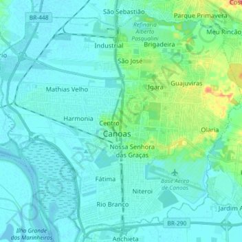
Name: Canoas topographic map, elevation, terrain.
Location: Canoas, Rio Grande do Sul, Região Sul, Brasil (-29.97182 -51.24919 -29.85887 -51.10604)
Average elevation: 12 m
Minimum elevation: -1 m
Maximum elevation: 86 m
Thank you for supporting this site ❤️
Make a donation
Make a donation
Gear up for your next adventure:
As an Amazon Associate, this site earns from qualifying purchases at no extra cost to you.