Geolocate

Buritis topographic map

Click on the map to display elevation.

About this map

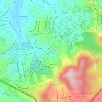
Name: Buritis topographic map, elevation, terrain.

Location: Buritis, Regional Oeste, Belo Horizonte, Minas Gerais, Região Sudeste, Brasil (-19.98594 -43.98150 -19.96610 -43.95852)

Average elevation: 1,019 m

Minimum elevation: 889 m

Maximum elevation: 1,237 m

Other topographic maps

Click on a map to view its topography, its elevation and its terrain.

Serra do Curral

Brasil > Minas Gerais > Belo Horizonte

Average elevation: 1,115 m

Gear up for your next adventure:

Family Camping Tent - Spacious tent suitable for family camping trips
🥾Trail Hiking Shoes - Durable shoes designed for rugged trails
👟Trail Running Shoes - Agile footwear for fast-paced topographic exploration
🥾Hiking Shorts - Breathable shorts suitable for summer hikes
🧭Orienteering Kit - Tools for map reading and navigation in the wild

As an Amazon Associate, this site earns from qualifying purchases at no extra cost to you.