
Londonderry/Derry topographic map
Interactive map
Click on the map to display elevation.
About this map
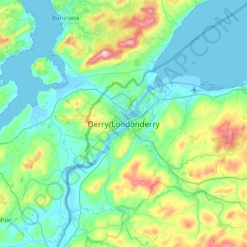
Name: Londonderry/Derry topographic map, elevation, terrain.
Average elevation: 88 m
Minimum elevation: -5 m
Maximum elevation: 478 m
Derry is characterised by its distinctively hilly topography. The River Foyle forms a deep valley as it flows through the city, making Derry a place of very steep streets and sudden, startling views. The original walled city of Londonderry lies on a hill on the west bank of the River Foyle. In the past, the river branched and enclosed this wooded hill as an island; over the centuries, however, the western branch of the river dried up and became a low-lying and boggy district that is now called the Bogside.