
Make a donation
Gear up for your next adventure:
As an Amazon Associate, this site earns from qualifying purchases at no extra cost to you.
Bornem topographic map
Click on the map to display elevation.
Make a donation
Gear up for your next adventure:
As an Amazon Associate, this site earns from qualifying purchases at no extra cost to you.
About this map
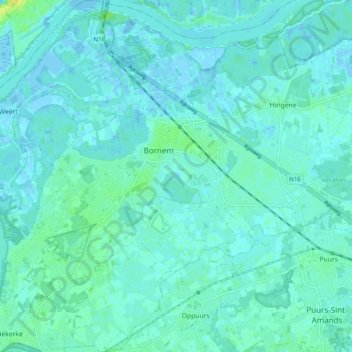
Name: Bornem topographic map, elevation, terrain.
Location: Bornem, Mechelen, Antwerpen, Vlaanderen, 2880, België (51.05988 4.18283 51.12168 4.27958)
Average elevation: 4 m
Minimum elevation: -4 m
Maximum elevation: 19 m
Make a donation
Gear up for your next adventure:
As an Amazon Associate, this site earns from qualifying purchases at no extra cost to you.
Other topographic maps
Click on a map to view its topography, its elevation and its terrain.
Buitenland
België > Antwerpen > Mechelen > Bornem
De enige boerderij die eind 18e eeuw in Buitenland stond, behoorde aan de familie Merckx. Philip Merckx (1778-1863) begon er met het telen van wissen en het vlechten van manden. In 1845 startte hij samen met Gaspar Broeckx een professionele mandenvlechterij: "De Compagnie". Frans Merckx (zoon van Philip en…
Average elevation: 6 m