Geolocate

Mosgiel topographic map

Click on the map to display elevation.

About this map
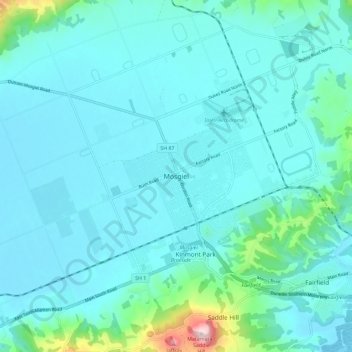
Name: Mosgiel topographic map, elevation, terrain.

Location: Mosgiel, Dunedin City, Otago, 9024, New Zealand (-45.91498 170.30735 -45.83498 170.38735)

Average elevation: 55 m

Minimum elevation: -1 m

Maximum elevation: 464 m

Other topographic maps

Click on a map to view its topography, its elevation and its terrain.

Logan Park

New Zealand > Otago > Dunedin City > Dunedin

Average elevation: 44 m

Waitati River

New Zealand > Otago > Dunedin City > Waitati

Average elevation: 259 m

Dunedin

New Zealand > Otago > Dunedin City

Average elevation: 143 m

Otago Harbour

New Zealand > Otago > Dunedin City > Dunedin

Average elevation: 113 m

Cragieburn

New Zealand > Otago > Dunedin City

Average elevation: 203 m

Gear up for your next adventure:

🕶️Polarized Sunglasses - Protect your eyes with durable polarized lenses
🥾Hiking Shorts - Breathable shorts suitable for summer hikes
🔨Vehicle Emergency Tool - Safety tool for remote road trips to trailheads
🥾Waterproof Trail Shoes - Shoes designed to handle wet terrain
🎒Hiking Daypack - Lightweight and durable backpacks for day trips and excursions

As an Amazon Associate, this site earns from qualifying purchases at no extra cost to you.