
Las Nubes topographic map
Click on the map to display elevation.
About this map
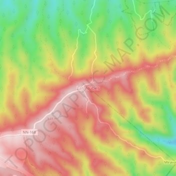
Name: Las Nubes topographic map, elevation, terrain.
Location: Las Nubes, Managua, 13087, Nicaragua (11.98915 -86.30422 12.02915 -86.26422)
Average elevation: 782 m
Minimum elevation: 591 m
Maximum elevation: 929 m
Other topographic maps
Click on a map to view its topography, its elevation and its terrain.
Managua
Managua's city area extends about 544 square kilometers (210 square miles), essentially south from the south shore of Lake Managua. The lakeshore is at an altitude of 55 meters (180 feet) above sea level, and the city climbs as it gets towards the Sierras de Managua further south where it is over 700 meters…
Average elevation: 223 m