
Make a donation
Gear up for your next adventure:
As an Amazon Associate, this site earns from qualifying purchases at no extra cost to you.
Campo Alegre topographic map
Click on the map to display elevation.
Make a donation
Gear up for your next adventure:
As an Amazon Associate, this site earns from qualifying purchases at no extra cost to you.
About this map
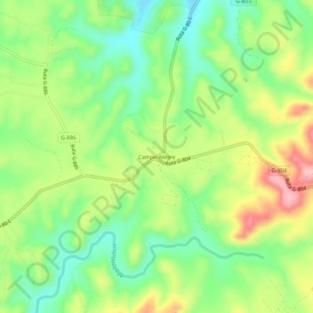
Name: Campo Alegre topographic map, elevation, terrain.
Average elevation: 102 m
Minimum elevation: 35 m
Maximum elevation: 199 m
Make a donation
Gear up for your next adventure:
As an Amazon Associate, this site earns from qualifying purchases at no extra cost to you.
Other topographic maps
Click on a map to view its topography, its elevation and its terrain.
Parque Tricao
Chile > Región de Valparaíso > Provincia de San Antonio > Santo Domingo
Average elevation: 76 m
Santuario de la Naturaleza Humedal Río Maipo
Chile > Región de Valparaíso > Provincia de San Antonio > Santo Domingo > Rocas de Santo Domingo
Average elevation: 11 m
Reserva Nacional El Yali
Chile > Región de Valparaíso > Provincia de San Antonio > Santo Domingo
Average elevation: 32 m