
Make a donation
Gear up for your next adventure:
As an Amazon Associate, this site earns from qualifying purchases at no extra cost to you.
Kangju Kangri topographic map
Click on the map to display elevation.
Make a donation
Gear up for your next adventure:
As an Amazon Associate, this site earns from qualifying purchases at no extra cost to you.
Kangju Kangri
Kangju Kangri is a mountain in the Karakoram Range of Asia located in the union territory of Ladakh, India. With a summit elevation of 6,725 meters above sea level, it is the highest peak of the Pangong range, a subrange of the Karakoram. Kangju Kangri rises over the winding, tri-headed Kangju glacier and Pangong Lake to the east.
Make a donation
Gear up for your next adventure:
As an Amazon Associate, this site earns from qualifying purchases at no extra cost to you.
About this map
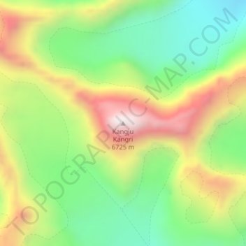
Name: Kangju Kangri topographic map, elevation, terrain.
Location: Kangju Kangri, Leh Tehsil, Leh district, Ladakh, India (33.72521 78.52739 33.72531 78.52749)
Average elevation: 6,190 m
Minimum elevation: 5,820 m
Maximum elevation: 6,694 m
Make a donation
Gear up for your next adventure:
As an Amazon Associate, this site earns from qualifying purchases at no extra cost to you.
Other topographic maps
Click on a map to view its topography, its elevation and its terrain.
Indus
India > Ladakh > Leh Tehsil
In the uppermost, highest part of the Indus River basin there are relatively few genera and species: Diptychus, Ptychobarbus, Schizopyge, Schizopygopsis and Schizothorax snowtrout, Triplophysa loaches, and the catfish Glyptosternon reticulatum. Going downstream these are soon joined by the golden mahseer Tor…
Average elevation: 4,192 m