
Make a donation
Gear up for your next adventure:
As an Amazon Associate, this site earns from qualifying purchases at no extra cost to you.
Seifersdorf topographic map
Click on the map to display elevation.
Make a donation
Gear up for your next adventure:
As an Amazon Associate, this site earns from qualifying purchases at no extra cost to you.
Seifersdorf
Seifersdorf liegt zwischen 285 und 404,3 m ü. NN (Geierswacht). Östlich des Dorfes fließt die Rote Weißeritz, und es grenzt die Dippoldiswalder Heide an die Ortsfluren. Südwestlich von Seifersdorf befindet sich das Waldgebiet Paulsdorfer Heide mit der Erashöhe (428 m) als höchster Erhebung. An den Ort grenzen Borlas, Oelsa, Spechtritz, Malter, Paulsdorf und Seifen.
Make a donation
Gear up for your next adventure:
As an Amazon Associate, this site earns from qualifying purchases at no extra cost to you.
About this map
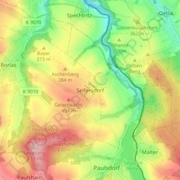
Name: Seifersdorf topographic map, elevation, terrain.
Average elevation: 359 m
Minimum elevation: 284 m
Maximum elevation: 436 m
Make a donation
Gear up for your next adventure:
As an Amazon Associate, this site earns from qualifying purchases at no extra cost to you.
Other topographic maps
Click on a map to view its topography, its elevation and its terrain.
Dippoldiswalde
Deutschland > Sachsen > Sächsische Schweiz-Osterzgebirge > Dippoldiswalde
Average elevation: 446 m
Talsperre Malter
Deutschland > Sachsen > Sächsische Schweiz-Osterzgebirge > Dippoldiswalde > Malter
Average elevation: 368 m
01744
Deutschland > Sachsen > Sächsische Schweiz-Osterzgebirge > Dippoldiswalde
Average elevation: 498 m