Geolocate

La Joya topographic map

Click on the map to display elevation.

About this map

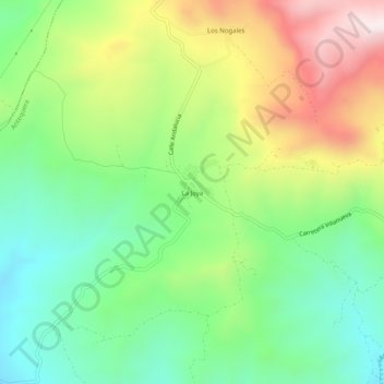
Name: La Joya topographic map, elevation, terrain.

Location: La Joya, Antequera, Malaga, Andalusia, Spain (36.91148 -4.64317 36.95148 -4.60317)

Average elevation: 717 m

Minimum elevation: 444 m

Maximum elevation: 1,156 m

Other topographic maps

Click on a map to view its topography, its elevation and its terrain.

Sierra de Huma

Spain > Andalusia > Antequera > Antequera

Average elevation: 714 m

Gear up for your next adventure:

💡Portable Camping Lamp - Rechargeable lamp for campsite lighting
🧴Sunscreen SPF - Broad-spectrum sunscreen for outdoor activities
💧Hydration Bladder - Hands-free hydration solution for long treks
🧦Thermal Socks - Warm socks for winter hiking or camping
🧤Insulated Winter Gloves - Heavy-duty protection for sub-zero Canadian adventures

As an Amazon Associate, this site earns from qualifying purchases at no extra cost to you.