
Make a donation
Gear up for your next adventure:
As an Amazon Associate, this site earns from qualifying purchases at no extra cost to you.
Eiterfeld topographic map
Click on the map to display elevation.
Make a donation
Gear up for your next adventure:
As an Amazon Associate, this site earns from qualifying purchases at no extra cost to you.
About this map
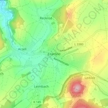
Name: Eiterfeld topographic map, elevation, terrain.
Location: Eiterfeld, Landkreis Fulda, Hessen, 36132, Deutschland (50.74183 9.77975 50.78183 9.81975)
Average elevation: 340 m
Minimum elevation: 262 m
Maximum elevation: 472 m
Make a donation
Gear up for your next adventure:
As an Amazon Associate, this site earns from qualifying purchases at no extra cost to you.
Other topographic maps
Click on a map to view its topography, its elevation and its terrain.
Fürsteneck
Deutschland > Hessen > Landkreis Fulda > Eiterfeld > Fürsteneck
Die Höhenburg liegt im Hessischen Kegelspiel am Westrand der kleinen Hochebene Wittfeld. Sie befindet sich am Nordwestrand des 1,8 km nordnordöstlich vom Eiterfelder Kernort gelegenen Weilers Fürsteneck auf dem Hausberg (406,5 m ü. NHN).
Average elevation: 346 m