
Thank you for supporting this site ❤️
Make a donation
Make a donation
Gear up for your next adventure:
As an Amazon Associate, this site earns from qualifying purchases at no extra cost to you.
Nanna topographic map
Click on the map to display elevation.
Thank you for supporting this site ❤️
Make a donation
Make a donation
Gear up for your next adventure:
As an Amazon Associate, this site earns from qualifying purchases at no extra cost to you.
About this map
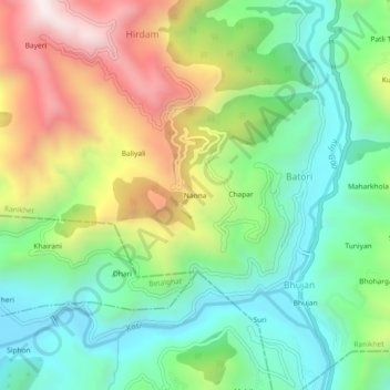
Name: Nanna topographic map, elevation, terrain.
Location: Nanna, Batori, Ranikhet, Almora, Uttarakhand, 263135, India (29.50108 79.44557 29.54108 79.48557)
Average elevation: 1,200 m
Minimum elevation: 846 m
Maximum elevation: 1,809 m
Thank you for supporting this site ❤️
Make a donation
Make a donation
Gear up for your next adventure:
As an Amazon Associate, this site earns from qualifying purchases at no extra cost to you.