
Make a donation
Gear up for your next adventure:
As an Amazon Associate, this site earns from qualifying purchases at no extra cost to you.
Oberndorf am Neckar topographic map
Click on the map to display elevation.
Make a donation
Gear up for your next adventure:
As an Amazon Associate, this site earns from qualifying purchases at no extra cost to you.
Oberndorf am Neckar
1852 war die Not so groß, dass eine Suppenanstalt eingerichtet werden musste. Die Auswanderungswelle nach Amerika erreichte in diesem Jahr ihren Höhepunkt, die Bevölkerung Oberndorfs ging von 1864 Einwohnern auf 1688 Einwohner zurück.
Make a donation
Gear up for your next adventure:
As an Amazon Associate, this site earns from qualifying purchases at no extra cost to you.
About this map
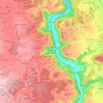
Name: Oberndorf am Neckar topographic map, elevation, terrain.
Average elevation: 617 m
Minimum elevation: 442 m
Maximum elevation: 718 m
Make a donation
Gear up for your next adventure:
As an Amazon Associate, this site earns from qualifying purchases at no extra cost to you.