Geolocate

Attaching topographic map

Click on the map to display elevation.

About this map

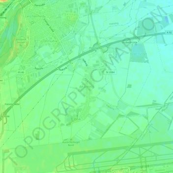
Name: Attaching topographic map, elevation, terrain.

Location: Attaching, Freising, Landkreis Freising, Bayern, 85356, Deutschland (48.35842 11.75416 48.39842 11.79416)

Average elevation: 443 m

Minimum elevation: 431 m

Maximum elevation: 463 m

Other topographic maps

Click on a map to view its topography, its elevation and its terrain.

Gear up for your next adventure:

🧭GPS Handheld Device - Reliable GPS navigation for outdoor adventures
🚑Survival Whistle - Signal for help across long distances in mountains
Camping Coffee Maker - Brew fresh coffee anywhere on the topographic map
🔪Outdoor Multitool - Versatile tool for repairs and food prep in the wild
🥾Mountain Hiking Boots - High-traction boots for rocky terrain

As an Amazon Associate, this site earns from qualifying purchases at no extra cost to you.