
Armada Township topographic map
Click on the map to display elevation.
About this map
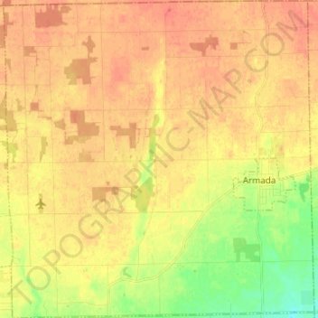
Name: Armada Township topographic map, elevation, terrain.
Average elevation: 233 m
Minimum elevation: 206 m
Maximum elevation: 247 m
Other topographic maps
Click on a map to view its topography, its elevation and its terrain.
Sterling Heights
United States > Michigan > Macomb County > Sterling Heights > Sterling Heights
Average elevation: 205 m
Chesterfield Shores
United States > Michigan > Macomb County > Chesterfield Township
Average elevation: 178 m
Forest Lake
United States > Michigan > Macomb County > Shelby Charter Township
Average elevation: 202 m