Geolocate

Bintulu topographic map

Click on the map to display elevation.

About this map

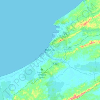
Name: Bintulu topographic map, elevation, terrain.

Location: Bintulu, Bintulu Division, Sarawak, 97000, Malaysia (3.02743 112.88728 3.34743 113.20728)

Average elevation: 18 m

Minimum elevation: -1 m

Maximum elevation: 225 m

Other topographic maps

Click on a map to view its topography, its elevation and its terrain.

Similajau National Park

Malaysia > Sarawak > Bintulu

Average elevation: 29 m

Gear up for your next adventure:

🦯Trekking Poles - Reduced impact on joints for steep topographic climbs
🧤Insulated Winter Gloves - Heavy-duty protection for sub-zero Canadian adventures
🦶Hiking Shoe Insoles - Added support for high arches and long days on feet
💡Portable Camping Lamp - Rechargeable lamp for campsite lighting
Camping Essentials - All-in-one gear for a comfortable camping trip

As an Amazon Associate, this site earns from qualifying purchases at no extra cost to you.