
Lefkada topographic map
Click on the map to display elevation.
About this map
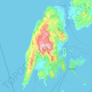
Name: Lefkada topographic map, elevation, terrain.
Average elevation: 111 m
Minimum elevation: -2 m
Maximum elevation: 1,160 m
Other topographic maps
Click on a map to view its topography, its elevation and its terrain.
Gyra (Anna)
Greece > Ioanian Islands > Lefkada Regional Unit > Municipal Unit of Lefkada
Average elevation: 0 m
Vasiliki
Greece > Ioanian Islands > Lefkada Regional Unit > Municipal Unit of Apollonioi
Average elevation: 114 m