Geolocate

Fairfield Island topographic map

Click on the map to display elevation.

About this map

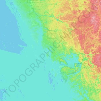
Name: Fairfield Island topographic map, elevation, terrain.

Location: Fairfield Island, Carling Township, Parry Sound District, Central Ontario, Ontario, Canada (45.10430 -80.63167 45.74430 -79.99167)

Average elevation: 199 m

Minimum elevation: 172 m

Maximum elevation: 306 m

Parry Sound District trails, hiking, mountain biking, running and outdoor activities

Other topographic maps

Click on a map to view its topography, its elevation and its terrain.

Gear up for your next adventure:

🎒Backpack Rain Cover - External shield to keep your entire pack dry
🥾Hiking Shorts - Breathable shorts suitable for summer hikes
Lightweight Camping Tent - Portable shelter optimized for Canadian backcountry camping
🔦LED Flashlight - Powerful and long-lasting flashlight for camping and emergencies
🥾Trekking Poles - Adjustable trekking poles to reduce knee stress and improve stability

As an Amazon Associate, this site earns from qualifying purchases at no extra cost to you.