Geolocate

Parque Centenario topographic map

Click on the map to display elevation.

About this map

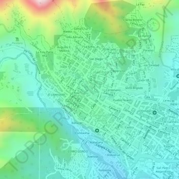
Name: Parque Centenario topographic map, elevation, terrain.

Location: Parque Centenario, Centenario, Comuna 1 - Centro, Comuna 2 - Calambeo, Perímetro Urbano Ibagué, Ibagué, Centro, Tolima, Colombia (4.44605 -75.24400 4.44928 -75.23992)

Average elevation: 1,295 m

Minimum elevation: 1,173 m

Maximum elevation: 1,625 m

Other topographic maps

Click on a map to view its topography, its elevation and its terrain.

Gear up for your next adventure:

🔋Lithium AA Batteries - Long-lasting power that performs in extreme cold
🏕️Camping Hammock - Integrated protection for sleeping between trees
🛏️Camping Sleeping Mat - Comfortable mats for sleeping outdoors
🧳Compression Sacks - Maximize space in your backpack by shrinking gear
🎒Hiking Backpack - Lightweight and ergonomic backpacks for day hikes or multi-day treks

As an Amazon Associate, this site earns from qualifying purchases at no extra cost to you.