Geolocate

Herpen topographic map

Click on the map to display elevation.

About this map

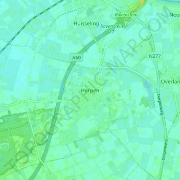
Name: Herpen topographic map, elevation, terrain.

Location: Herpen, Oss, Noord-Brabant, Nederland, 5373, Nederland (51.75282 5.62229 51.79282 5.66229)

Average elevation: 8 m

Minimum elevation: 4 m

Maximum elevation: 18 m

Gear up for your next adventure:

👖Convertible Hiking Pants - Zip-off legs to adapt to changing weather conditions
💧Hydration Pack - Hands-free hydration system for long hikes
🧭Orienteering Kit - Tools for map reading and navigation in the wild
💡LED Headlamp - Hands-free illumination for night hiking and camping
📷Outdoor Action Camera - Capture high-elevation views and rugged adventures

As an Amazon Associate, this site earns from qualifying purchases at no extra cost to you.