Geolocate

Sarpara topographic map

Click on the map to display elevation.

About this map

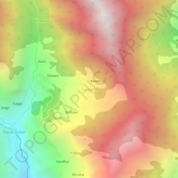
Name: Sarpara topographic map, elevation, terrain.

Location: Sarpara, Rampur, Shimla, Himachal Pradesh, India (31.53068 77.69807 31.57068 77.73807)

Average elevation: 2,390 m

Minimum elevation: 1,365 m

Maximum elevation: 3,237 m

Other topographic maps

Click on a map to view its topography, its elevation and its terrain.

Daranghati WLS

India > Himachal Pradesh > Rampur > Kasha

Average elevation: 3,565 m

Gear up for your next adventure:

🧣Merino Neck Gaiter - Protects against wind, sun, and cold at high altitudes
🧭Orienteering Kit - Tools for map reading and navigation in the wild
🧤Thermal Hiking Gloves - Grip-enhanced gloves for cold-weather altitude trekking
🌡️Emergency Mylar Blankets - Compact thermal protection for unexpected nights outdoors
Bushcraft Tarp - Versatile emergency shelter or gear protection

As an Amazon Associate, this site earns from qualifying purchases at no extra cost to you.