
Vic-sur-Cère topographic map
Click on the map to display elevation.
Vic-sur-Cère
La vallée est située entre 673 mètres (en limite de Thiézac) et 645 mètres d'altitude (en limite de Polminhac), tandis que les deux montagnes culminent à 1 263 mètres (puy de Quenouille, au nord), et à 1 228 mètres d'altitude (via Celtica), ce qui fait 618 mètres de dénivellation.
About this map
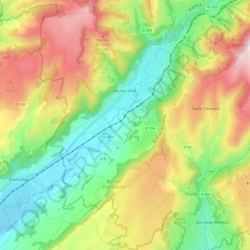
Name: Vic-sur-Cère topographic map, elevation, terrain.
Average elevation: 913 m
Minimum elevation: 630 m
Maximum elevation: 1,312 m
Other topographic maps
Click on a map to view its topography, its elevation and its terrain.
Puy Mary
France > Auvergne-Rhône-Alpes > Cantal > Le Falgoux
Le puy Mary est un sommet des monts du Cantal, vestige du plus grand stratovolcan d'Europe. Il culmine à 1 783 mètres d'altitude.
Average elevation: 1,413 m
Font de Cère
France > Auvergne-Rhône-Alpes > Cantal > Saint-Jacques-des-Blats
Average elevation: 1,334 m
Marchal
France > Auvergne-Rhône-Alpes > Cantal > Champs-sur-Tarentaine-Marchal
Average elevation: 799 m
Les Troix Croix
France > Auvergne-Rhône-Alpes > Cantal > Le Rouget-Pers > Pers
Average elevation: 595 m
Col de Prat-de-Bouc
France > Auvergne-Rhône-Alpes > Cantal > Albepierre-Bredons
Le col de Prat-de-Bouc est un col à 1 396 mètres d'altitude situé dans les monts du Cantal, dans le département du même nom, au sein du Massif central. Il se trouve à l'est du Plomb du Cantal. Au pied de celui-ci se trouve la station du Lioran et le domaine nordique de Prat de Bouc - Haute Planèze.
Average elevation: 1,442 m
La Boudie
France > Auvergne-Rhône-Alpes > Cantal > Saint-Julien-de-Jordanne
Average elevation: 1,157 m
Super Lioran
France > Auvergne-Rhône-Alpes > Cantal
Historiquement et administrativement, il est rattaché au Valagnon (commune de Laveissière) en Haute-Auvergne. La station s'étend sur 150 ha, de 1 160 à 1 821 m d'altitude, principalement sur la commune de Laveissière mais aussi sur trois autres : Albepierre-Bredons (station de Prat de Bouc), Paulhac et…
Average elevation: 1,367 m
Brèche de Roland
France > Auvergne-Rhône-Alpes > Cantal > Mandailles-Saint-Julien
Average elevation: 1,395 m
Puy de Bassierou
France > Auvergne-Rhône-Alpes > Cantal > Saint-Projet-de-Salers
Average elevation: 1,190 m
Plomb du Cantal
France > Auvergne-Rhône-Alpes > Cantal > Albepierre-Bredons
Le Plomb du Cantal est le point culminant des monts du Cantal. Ses 1 855 mètres d'altitude en font le deuxième plus haut sommet du Massif central après le puy de Sancy (1 885 m). Situé au centre du département français du Cantal, il constitue la ligne de crête entre les vallées de la Cère, de…
Average elevation: 1,578 m
Puy de l'Usclade
France > Auvergne-Rhône-Alpes > Cantal > Mandailles-Saint-Julien
Average elevation: 1,259 m
Le Chassan
France > Auvergne-Rhône-Alpes > Cantal > Val d'Arcomie > Faverolles
Average elevation: 882 m
La Roche-Canilhac
France > Auvergne-Rhône-Alpes > Cantal > Saint-Rémy-de-Chaudes-Aigues
Average elevation: 1,104 m