
San Jacinto Mountain topographic map
Interactive map
Click on the map to display elevation.
About this map
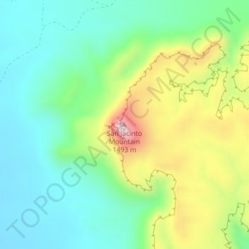
Name: San Jacinto Mountain topographic map, elevation, terrain.
Location: San Jacinto Mountain, Presidio County, Texas, USA (29.75457 -103.95496 29.75467 -103.95486)
Average elevation: 1,233 m
Minimum elevation: 1,096 m
Maximum elevation: 1,514 m
Other topographic maps
Click on a map to view its topography, its elevation and its terrain.
Point Loma
USA > Texas > Point Loma
Point Loma, San Patricio County, Texas, 78368, USA
Average elevation: 34 m
Denny Mountain
Denny Mountain, Nacogdoches County, Texas, 75760, USA
Average elevation: 137 m
Karnes City
USA > Texas > Karnes City
Karnes City, Karnes County, Texas, 78118, USA
Average elevation: 122 m
Guadalupe Peak
Guadalupe Peak, Culberson County, Texas, 79847, USA
Average elevation: 2,151 m