Geolocate

Farmer topographic map

Click on the map to display elevation.

About this map

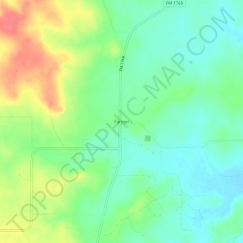
Name: Farmer topographic map, elevation, terrain.

Location: Farmer, Young County, Texas, United States (33.32650 -98.57506 33.36650 -98.53506)

Average elevation: 357 m

Minimum elevation: 335 m

Maximum elevation: 395 m

Gear up for your next adventure:

Camping Essentials - All-in-one gear for a comfortable camping trip
🧥Waterproof Pants - Keep dry during rainy hiking conditions
🧼Biodegradable Camp Soap - Environmentally friendly cleaning for gear and body
🥾Hiking Shorts - Breathable shorts suitable for summer hikes
🔦UV Flashlight - Detect minerals or specific insects in the dark

As an Amazon Associate, this site earns from qualifying purchases at no extra cost to you.