Geolocate

Sparta topographic map

Click on the map to display elevation.

About this map

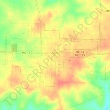
Name: Sparta topographic map, elevation, terrain.

Location: Sparta, Christian County, Missouri, 65753, United States (36.99275 -93.10026 37.00850 -93.06562)

Average elevation: 424 m

Minimum elevation: 390 m

Maximum elevation: 444 m

Other topographic maps

Click on a map to view its topography, its elevation and its terrain.

Chadwick

United States > Missouri > Christian County

Average elevation: 385 m

Gear up for your next adventure:

🥾Mountain Hiking Shoes - Shoes with superior grip for mountainous terrain
Camping Coffee Maker - Brew fresh coffee anywhere on the topographic map
🔭Outdoor Binoculars - Lightweight binoculars for birdwatching and hiking
Tent Footprint - Protect tent floor and increase durability
🔭Compact Binoculars - Lightweight optics for scouting trails and wildlife

As an Amazon Associate, this site earns from qualifying purchases at no extra cost to you.