
Thank you for supporting this site ❤️
Make a donation
Make a donation
Gear up for your next adventure:
As an Amazon Associate, this site earns from qualifying purchases at no extra cost to you.
Hennersdorf topographic map
Click on the map to display elevation.
Thank you for supporting this site ❤️
Make a donation
Make a donation
Gear up for your next adventure:
As an Amazon Associate, this site earns from qualifying purchases at no extra cost to you.
About this map
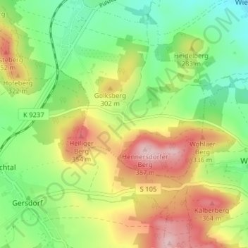
Name: Hennersdorf topographic map, elevation, terrain.
Location: Hennersdorf, Kamenz, Bautzen, Sachsen, 01917, Deutschland (51.21864 14.06318 51.25864 14.10318)
Average elevation: 263 m
Minimum elevation: 175 m
Maximum elevation: 382 m
Thank you for supporting this site ❤️
Make a donation
Make a donation
Gear up for your next adventure:
As an Amazon Associate, this site earns from qualifying purchases at no extra cost to you.