
Make a donation
Gear up for your next adventure:
As an Amazon Associate, this site earns from qualifying purchases at no extra cost to you.
Dent topographic map
Click on the map to display elevation.
Make a donation
Gear up for your next adventure:
As an Amazon Associate, this site earns from qualifying purchases at no extra cost to you.
About this map
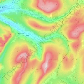
Name: Dent topographic map, elevation, terrain.
Location: Dent, South Lakeland, Cumbria, England, United Kingdom (54.22287 -2.54253 54.31130 -2.31549)
Average elevation: 388 m
Minimum elevation: 110 m
Maximum elevation: 733 m
Make a donation
Gear up for your next adventure:
As an Amazon Associate, this site earns from qualifying purchases at no extra cost to you.
Other topographic maps
Click on a map to view its topography, its elevation and its terrain.
Claife Heights
United Kingdom > England > Cumbria > South Lakeland
Claife Heights is an upland area in the Lake District, near to Windermere in Cumbria, England. It has a topographic prominence of 177 metres (581 ft) so is classified as a Marilyn (a hill with prominence of at least 150m).
Average elevation: 141 m