
Province of Arequipa topographic map
Interactive map
Click on the map to display elevation.
About this map
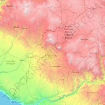
Name: Province of Arequipa topographic map, elevation, terrain.
Location: Province of Arequipa, Arequipa, Peru (-16.79955 -72.28353 -15.92189 -70.80408)
Average elevation: 3,028 m
Minimum elevation: 0 m
Maximum elevation: 6,207 m
Other topographic maps
Click on a map to view its topography, its elevation and its terrain.
José Luis Bustamante y Rivero
José Luis Bustamante y Rivero, Province of Arequipa, Arequipa, Peru
Average elevation: 2,351 m
Jacobo Hunter
Jacobo Hunter, Province of Arequipa, Arequipa, Peru
Average elevation: 2,332 m
Ciudad Satélite
Peru > Arequipa > José Luis Bustamante y Rivero > Ciudad Satélite
Ciudad Satélite, José Luis Bustamante y Rivero, Province of Arequipa, Arequipa, 04009, Peru
Average elevation: 2,373 m
Micaela Bastidas
Peru > Arequipa > Micaela Bastidas
Micaela Bastidas, Arequipa, 0154, Peru
Average elevation: 2,198 m
Province of Caylloma
Province of Caylloma, Maca, Caylloma, Arequipa, Peru
Average elevation: 4,319 m