Geolocate

Fahma topographic map

Click on the map to display elevation.

About this map

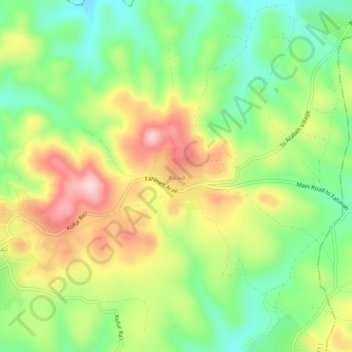
Name: Fahma topographic map, elevation, terrain.

Location: Fahma, Area A, West Bank, 072, Palestinian Territory (32.36274 35.15984 32.40274 35.19984)

Average elevation: 374 m

Minimum elevation: 271 m

Maximum elevation: 510 m

Gear up for your next adventure:

🐕Hiking Dog Pack - Let your canine companion carry their own water and food
🥾Lightweight Hiking Boots - Boots for comfort and mobility on long hikes
🧦Outdoor Socks - Durable socks designed for hiking and outdoor sports
🧴First Aid Kit - Essential first aid supplies for outdoor emergencies
🛌Insulated Sleeping Pad - Critical thermal barrier between you and the cold ground

As an Amazon Associate, this site earns from qualifying purchases at no extra cost to you.