
Make a donation
Gear up for your next adventure:
As an Amazon Associate, this site earns from qualifying purchases at no extra cost to you.
Luling topographic map
Click on the map to display elevation.
Make a donation
Gear up for your next adventure:
As an Amazon Associate, this site earns from qualifying purchases at no extra cost to you.
Luling
Luling is located at 29°54′48″N 90°21′50″W / 29.91333°N 90.36389°W / 29.91333; -90.36389 (29.913260, -90.364008) and has an elevation of 7 feet (2.1 m).
Make a donation
Gear up for your next adventure:
As an Amazon Associate, this site earns from qualifying purchases at no extra cost to you.
About this map
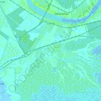
Name: Luling topographic map, elevation, terrain.
Location: Luling, St. Charles Parish, Louisiana, 70070, United States (29.85296 -90.41822 29.94880 -90.28514)
Average elevation: 2 m
Minimum elevation: -5 m
Maximum elevation: 15 m
Make a donation
Gear up for your next adventure:
As an Amazon Associate, this site earns from qualifying purchases at no extra cost to you.
Other topographic maps
Click on a map to view its topography, its elevation and its terrain.
Mimosa Baseball and Tennis park
United States > Louisiana > St. Charles Parish > Luling > Mimosa Park
Average elevation: 3 m