Geolocate

Berghem topographic map

Click on the map to display elevation.

About this map

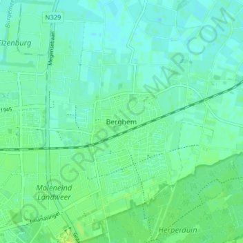
Name: Berghem topographic map, elevation, terrain.

Location: Berghem, Noord-Brabant, Nederland, 5351, Nederland (51.75096 5.55219 51.79096 5.59219)

Average elevation: 9 m

Minimum elevation: 4 m

Maximum elevation: 17 m

Gear up for your next adventure:

🥾Durable Hiking Shoes - Long-lasting shoes for frequent hiking
🛰️Satellite Messenger - Emergency communication for areas with no cell service
🧢Outdoor Cap - Protective cap for sun and rain during hikes
🍽️Titanium Camping Spork - Ultralight and indestructible eating utensil
🧼Biodegradable Camp Soap - Environmentally friendly cleaning for gear and body

As an Amazon Associate, this site earns from qualifying purchases at no extra cost to you.