Geolocate

Ruaka topographic map

Click on the map to display elevation.

About this map
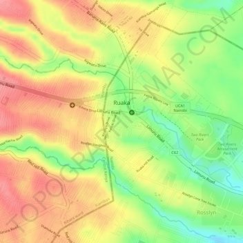
Name: Ruaka topographic map, elevation, terrain.

Location: Ruaka, Kiambaa, Kiambu, Kenya (-1.21379 36.76671 -1.20169 36.79327)

Average elevation: 1,753 m

Minimum elevation: 1,698 m

Maximum elevation: 1,790 m

Other topographic maps

Click on a map to view its topography, its elevation and its terrain.

Muchatha ward

Kenya > Kiambu > Kiambaa

Average elevation: 1,793 m

karuri

Kenya > Kiambu > Kiambaa > Karuri ward

Average elevation: 1,865 m

Ndenderu ward

Kenya > Kiambu > Kiambaa

Average elevation: 1,854 m

Cianda ward

Kenya > Kiambu > Kiambaa

Average elevation: 1,887 m

Gear up for your next adventure:

👟Sport Hiking Sandals - Breathable footwear for water crossings and camp rest
🥾Waterproof Trail Shoes - Shoes designed to handle wet terrain
🔭Compact Binoculars - Lightweight optics for scouting trails and wildlife
🔭Compact Monocular - One-handed bird watching and trail spotting
💧Hydration Bladder - Hands-free hydration solution for long treks

As an Amazon Associate, this site earns from qualifying purchases at no extra cost to you.