
Make a donation
Gear up for your next adventure:
As an Amazon Associate, this site earns from qualifying purchases at no extra cost to you.
Kohala topographic map
Click on the map to display elevation.
Make a donation
Gear up for your next adventure:
As an Amazon Associate, this site earns from qualifying purchases at no extra cost to you.
Kohala
In Kohala, the numerous dikes near the summit inhibit groundwater from seeping downslope to the northeast, where it naturally wants to go. Rather, the Kohala dike complex guides it northwest or southeast, down the axis of the rift zones, just like the surface water. On the other hand, the three smaller valleys between the large ones - Honopue, Honokea, and Honokane Iki - as well as the many smaller gulches which are not yet valleys, are deprived of groundwater by the orientation of the rift zone and its dikes. Without the large amount of water that is received by the bigger valleys, these valleys grow far more slowly. Due to its topography as essentially a flat crater floor surrounded by cones and fault scarps, the main caldera is affected relatively little by erosion from water.
Make a donation
Gear up for your next adventure:
As an Amazon Associate, this site earns from qualifying purchases at no extra cost to you.
About this map
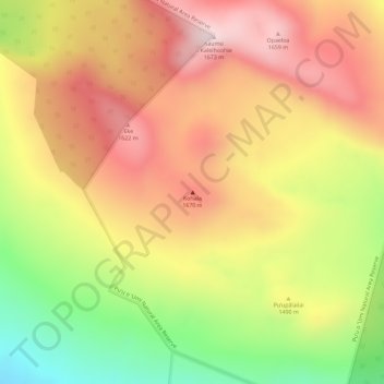
Name: Kohala topographic map, elevation, terrain.
Location: Kohala, Hawaiʻi County, Hawaii, United States (20.07494 -155.71874 20.07504 -155.71864)
Average elevation: 1,489 m
Minimum elevation: 1,233 m
Maximum elevation: 1,665 m
Make a donation
Gear up for your next adventure:
As an Amazon Associate, this site earns from qualifying purchases at no extra cost to you.
Other topographic maps
Click on a map to view its topography, its elevation and its terrain.
Make a donation
Gear up for your next adventure:
As an Amazon Associate, this site earns from qualifying purchases at no extra cost to you.
Kukuihaele CDP
United States > Hawaii > Hawaiʻi County
Kukuihaele is located on the north side of the island of Hawaii at 20°7′10″N 155°34′16″W / 20.11944°N 155.57111°W / 20.11944; -155.57111 (20.119536, -155.571160). It sits at an elevation of 730 feet (220 m) atop cliffs overlooking Waipio Bay. Hawaii Route 240 passes through the southern…
Average elevation: 173 m
Make a donation
Gear up for your next adventure:
As an Amazon Associate, this site earns from qualifying purchases at no extra cost to you.
Make a donation
Gear up for your next adventure:
As an Amazon Associate, this site earns from qualifying purchases at no extra cost to you.
Make a donation
Gear up for your next adventure:
As an Amazon Associate, this site earns from qualifying purchases at no extra cost to you.
Make a donation
Gear up for your next adventure:
As an Amazon Associate, this site earns from qualifying purchases at no extra cost to you.