Geolocate

Großbüchlberg topographic map

Click on the map to display elevation.

About this map

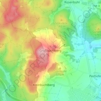
Name: Großbüchlberg topographic map, elevation, terrain.

Location: Großbüchlberg, Mitterteich, Mitterteich (VGem), Landkreis Tirschenreuth, Bayern, 95666, Deutschland (49.95214 12.20044 49.99214 12.24044)

Average elevation: 557 m

Minimum elevation: 495 m

Maximum elevation: 645 m

Other topographic maps

Click on a map to view its topography, its elevation and its terrain.

Gear up for your next adventure:

🛶Waterproof Dry Bags - Keep electronics and clothes dry during river crossings
🦌Outdoor Trail Camera - Monitor wildlife activity near your favorite spots
🦶Hiking Shoe Insoles - Added support for high arches and long days on feet
🧢Outdoor Cap - Protective cap for sun and rain during hikes
🧣Evaporative Cooling Towel - Beat the heat during intense summer climbs

As an Amazon Associate, this site earns from qualifying purchases at no extra cost to you.