Geolocate

Waterloo Township topographic map

Click on the map to display elevation.

About this map

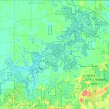
Name: Waterloo Township topographic map, elevation, terrain.

Location: Waterloo Township, Jackson County, Michigan, United States (42.30653 -84.25044 42.42479 -84.13114)

Average elevation: 287 m

Minimum elevation: 270 m

Maximum elevation: 349 m

Other topographic maps

Click on a map to view its topography, its elevation and its terrain.

Skiff Lake

United States > Michigan > Jackson County

Average elevation: 308 m

Honey Lake

United States > Michigan > Jackson County

Average elevation: 304 m

Olcott Lake

United States > Michigan > Jackson County

Average elevation: 289 m

Horton

United States > Michigan > Jackson County

Average elevation: 318 m

Leoni

United States > Michigan > Jackson County

Average elevation: 301 m

White Lake

United States > Michigan > Jackson County

Average elevation: 288 m

Gear up for your next adventure:

🧦Hiking Liner Socks - Thin base layer to prevent friction and blisters
🎒Hiking Backpack - Lightweight and ergonomic backpacks for day hikes or multi-day treks
🔪Outdoor Multitool - Versatile tool for repairs and food prep in the wild
💡Solar Camping Lamp - Eco-friendly lighting for campsites
Camping Essentials - All-in-one gear for a comfortable camping trip

As an Amazon Associate, this site earns from qualifying purchases at no extra cost to you.