
Make a donation
Gear up for your next adventure:
As an Amazon Associate, this site earns from qualifying purchases at no extra cost to you.
Deuel County topographic map
Click on the map to display elevation.
Make a donation
Gear up for your next adventure:
As an Amazon Associate, this site earns from qualifying purchases at no extra cost to you.
Deuel County
Deuel County lies on the east boundary line of South Dakota. Its east boundary line abuts the west boundary line of the state of Minnesota. Its terrain consists of rolling hills, sloped to the northeast. The area is largely devoted to agriculture. The county's highest elevation occurs on its upper west boundary line, at 1,936' (590m) ASL. The county has a total area of 637 square miles (1,650 km2), of which 623 square miles (1,610 km2) is land and 14 square miles (36 km2) (2.2%) is water.
Make a donation
Gear up for your next adventure:
As an Amazon Associate, this site earns from qualifying purchases at no extra cost to you.
About this map
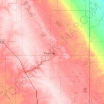
Name: Deuel County topographic map, elevation, terrain.
Location: Deuel County, South Dakota, United States (44.54365 -96.88553 44.97765 -96.45123)
Average elevation: 529 m
Minimum elevation: 334 m
Maximum elevation: 621 m
Make a donation
Gear up for your next adventure:
As an Amazon Associate, this site earns from qualifying purchases at no extra cost to you.
Other topographic maps
Click on a map to view its topography, its elevation and its terrain.
Make a donation
Gear up for your next adventure:
As an Amazon Associate, this site earns from qualifying purchases at no extra cost to you.