Geolocate

Inglis topographic map

Click on the map to display elevation.

About this map

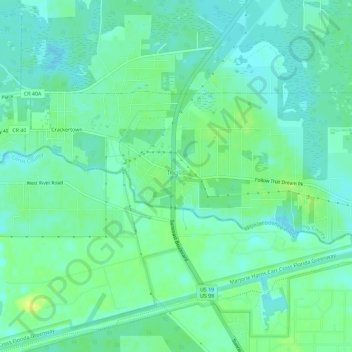
Name: Inglis topographic map, elevation, terrain.

Location: Inglis, Levy County, Florida, United States (29.01748 -82.69330 29.04185 -82.63608)

Average elevation: 10 m

Minimum elevation: 3 m

Maximum elevation: 21 m

Other topographic maps

Click on a map to view its topography, its elevation and its terrain.

Raleigh

United States > Florida > Levy County

Average elevation: 23 m

East Bronson

United States > Florida > Levy County

Average elevation: 27 m

East Bronson

United States > Florida > Levy County

Average elevation: 27 m

Crackertown

United States > Florida > Levy County > Inglis

Average elevation: 9 m

Cedar Keys

United States > Florida > Levy County

Average elevation: 3 m

Morriston

United States > Florida > Levy County

Average elevation: 20 m

Morriston

United States > Florida > Levy County

Average elevation: 20 m

Gear up for your next adventure:

🥾Trail Hiking Shoes - Durable shoes designed for rugged trails
🥾Hiking Boots - Sturdy boots providing ankle support and traction on rugged trails
🔭Outdoor Binoculars - Lightweight binoculars for birdwatching and hiking
Bushcraft Tarp - Versatile emergency shelter or gear protection
🥾Waterproof Hiking Boots - Essential footwear for rugged terrain and wet Canadian trails

As an Amazon Associate, this site earns from qualifying purchases at no extra cost to you.