
Ua Pou topographic map
Click on the map to display elevation.
Ua Pou
It is located about 50 km (30 mi.) south of Nuku Hiva, in the northern Marquesas. The center of the island is characterized by four high basalt pillars that reach high above the surrounding mountains. The highest of these pillars, Mount Oave (Mont Oave), reaches to 1,230 m (4,040 ft) above sea level and is the highest elevation in the Marquesas.
About this map
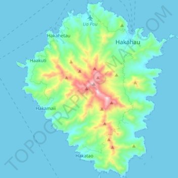
Name: Ua Pou topographic map, elevation, terrain.
Location: Ua Pou, Marquesas Islands, French Polynesia, France (-9.46723 -140.13578 -9.33490 -140.01976)
Average elevation: 127 m
Minimum elevation: -4 m
Maximum elevation: 919 m