Geolocate

Owatonna topographic map

Click on the map to display elevation.

About this map

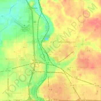
Name: Owatonna topographic map, elevation, terrain.

Location: Owatonna, Steele County, Minnesota, 55060, United States (44.05932 -93.28374 44.14574 -93.17906)

Average elevation: 361 m

Minimum elevation: 324 m

Maximum elevation: 392 m

Gear up for your next adventure:

🔋Emergency Crank Radio - Weather alerts and power without needing batteries
🛏️Sleeping Bag - Warm and compact sleeping bags for outdoor camping
🧦Crew Hiking Socks - Comfortable socks for long-distance hikes
🧢Outdoor Visor - Breathable visor for sunny hikes
🪑Ultralight Camping Stool - Compact seating for rest stops during long hikes

As an Amazon Associate, this site earns from qualifying purchases at no extra cost to you.