Geolocate

Peppara topographic map

Click on the map to display elevation.

About this map

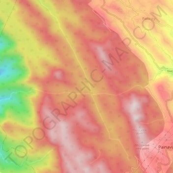
Name: Peppara topographic map, elevation, terrain.

Location: Peppara, Idukki, Kerala, India (9.85321 76.89631 9.89094 76.94869)

Average elevation: 751 m

Minimum elevation: 258 m

Maximum elevation: 992 m

Other topographic maps

Click on a map to view its topography, its elevation and its terrain.

Muttukadu

India > Kerala > Idukki

Average elevation: 1,096 m

Pettimudi Hill Top

India > Kerala > Idukki

Average elevation: 810 m

Muthirapuzha

India > Kerala > Idukki

Average elevation: 551 m

Idukki Dam

India > Kerala > Idukki

Average elevation: 701 m

Silent vally thodu

India > Kerala > Idukki

Average elevation: 1,668 m

Mattupetty Dam

India > Kerala > Idukki

Average elevation: 1,665 m

Malankara Dam

India > Kerala > Idukki

Average elevation: 59 m

Chokramudi

India > Kerala > Idukki

Average elevation: 1,670 m

Gear up for your next adventure:

Camping Essentials - All-in-one gear for a comfortable camping trip
🧊Insulated Water Bottle - Keeps drinks cold in summer and prevents freezing in winter
🔭Compact Binoculars - Lightweight optics for scouting trails and wildlife
🥾Trail Running Shoes - Lightweight and durable shoes for trail running
🧤Rechargeable Heated Gloves - Extreme warmth for Canadian winter expeditions

As an Amazon Associate, this site earns from qualifying purchases at no extra cost to you.