
Make a donation
Gear up for your next adventure:
As an Amazon Associate, this site earns from qualifying purchases at no extra cost to you.
Tramacastilla topographic map
Click on the map to display elevation.
Make a donation
Gear up for your next adventure:
As an Amazon Associate, this site earns from qualifying purchases at no extra cost to you.
About this map
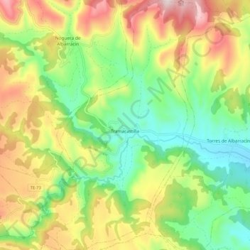
Name: Tramacastilla topographic map, elevation, terrain.
Average elevation: 1,439 m
Minimum elevation: 1,202 m
Maximum elevation: 1,780 m
Make a donation
Gear up for your next adventure:
As an Amazon Associate, this site earns from qualifying purchases at no extra cost to you.
Other topographic maps
Click on a map to view its topography, its elevation and its terrain.
Albarracín
España > Aragón > Sierra de Albarracín > Albarracín > Albarracín
Average elevation: 1,302 m
Alto de la Ceja del Campillo
España > Aragón > Sierra de Albarracín > Albarracín
Average elevation: 1,483 m
Alto del Tremedal
España > Aragón > Sierra de Albarracín > Orihuela del Tremedal
Average elevation: 1,714 m
Make a donation
Gear up for your next adventure:
As an Amazon Associate, this site earns from qualifying purchases at no extra cost to you.
Fuente Garcia (origen del Tajo)
España > Aragón > Sierra de Albarracín > Albarracín
Average elevation: 1,628 m
Make a donation
Gear up for your next adventure:
As an Amazon Associate, this site earns from qualifying purchases at no extra cost to you.