Geolocate

Plettenberg topographic map

Click on the map to display elevation.

Plettenberg

Plettenberg is located to the west of the Sauerland hills. The highest elevation of the town area is in the Ebbegebirge with 663 m above sea level, the lowest elevation with 194 m near Teindeln. The town is spread out between the four valleys of the rivers Lenne, Else, Oester [de] and Grüne.

Wikipedia (CC-BY-SA 3.0)

About this map

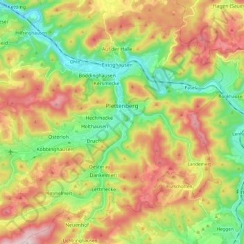
Name: Plettenberg topographic map, elevation, terrain.

Location: Plettenberg, Märkischer Kreis, North Rhine-Westphalia, 58840, Germany (51.15236 7.76717 51.25919 7.95129)

Average elevation: 378 m

Minimum elevation: 186 m

Maximum elevation: 630 m

Gear up for your next adventure:

🛰️Satellite Messenger - Emergency communication for areas with no cell service
📷Outdoor Action Camera - Capture high-elevation views and rugged adventures
🧼Travel Hand Sanitizer - Keep hands clean when water is scarce
🚑Survival Whistle - Signal for help across long distances in mountains
Backpacking Tent - Lightweight tent for long-distance hiking trips

As an Amazon Associate, this site earns from qualifying purchases at no extra cost to you.