Geolocate

Nglinggi topographic map

Click on the map to display elevation.

About this map

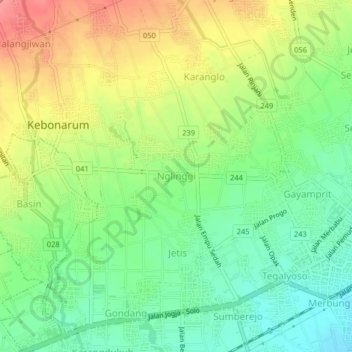
Name: Nglinggi topographic map, elevation, terrain.

Location: Nglinggi, Klaten, Central Java, Java, 57424, Indonesia (-7.72285 110.55748 -7.68285 110.59748)

Average elevation: 182 m

Minimum elevation: 145 m

Maximum elevation: 231 m

Other topographic maps

Click on a map to view its topography, its elevation and its terrain.

Jaten

Indonesia > Central Java > Klaten

Average elevation: 117 m

Bendo

Indonesia > Central Java > Klaten

Average elevation: 110 m

Bulan

Indonesia > Central Java > Klaten

Average elevation: 120 m

Depra Sentono

Indonesia > Central Java > Klaten

Average elevation: 102 m

Pugeran

Indonesia > Central Java > Klaten

Average elevation: 97 m

Kemalang

Indonesia > Central Java > Klaten

Average elevation: 844 m

Sidorejo

Indonesia > Central Java > Klaten

Average elevation: 1,110 m

Sajen

Indonesia > Central Java > Klaten

Average elevation: 105 m

Taji

Indonesia > Central Java > Klaten

Average elevation: 96 m

RT 11

Indonesia > Central Java > Klaten

Average elevation: 97 m

Gear up for your next adventure:

🧰Emergency Multi-Tool - Compact multi-tool for outdoor survival
🛰️Satellite Messenger - Emergency communication for areas with no cell service
🥾Mountaineering Boots - Supportive boots for climbing and high-altitude hiking
🧼Biodegradable Camp Soap - Environmentally friendly cleaning for gear and body
Lightweight Backpacking Tent - Compact tent for efficient hiking trips

As an Amazon Associate, this site earns from qualifying purchases at no extra cost to you.