Geolocate

Pontoria topographic map

Click on the map to display elevation.

About this map

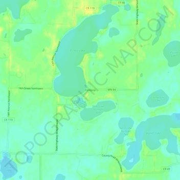
Name: Pontoria topographic map, elevation, terrain.

Location: Pontoria, Cass County, Minnesota, United States (46.84329 -94.35665 46.88329 -94.31665)

Average elevation: 409 m

Minimum elevation: 401 m

Maximum elevation: 420 m

Other topographic maps

Click on a map to view its topography, its elevation and its terrain.

Gull Lake

United States > Minnesota > Cass County > Lake Shore

Average elevation: 372 m

Cass Lake

United States > Minnesota > Cass County

Average elevation: 402 m

Walker

United States > Minnesota > Cass County

Average elevation: 415 m

Cass Lake

United States > Minnesota > Cass County

Average elevation: 402 m

Pine River

United States > Minnesota > Cass County

Average elevation: 395 m

Pine River

United States > Minnesota > Cass County

Average elevation: 395 m

Longville

United States > Minnesota > Cass County

Average elevation: 407 m

Gear up for your next adventure:

🛏️Sleeping Bag - Warm and compact sleeping bags for outdoor camping
🧢Sun Hat - Wide-brim hat for sun protection
🧥Thermal Layer - Insulating layer for cold outdoor conditions
🧦Thermal Socks - Warm socks for winter hiking or camping
🧥Waterproof Pants - Keep dry during rainy hiking conditions

As an Amazon Associate, this site earns from qualifying purchases at no extra cost to you.