
Make a donation
Gear up for your next adventure:
As an Amazon Associate, this site earns from qualifying purchases at no extra cost to you.
Schipkau topographic map
Click on the map to display elevation.
Make a donation
Gear up for your next adventure:
As an Amazon Associate, this site earns from qualifying purchases at no extra cost to you.
Schipkau
On September 19th, 2024 construction work on GICON High-Altitude Wind Turbine in Klettwitz wind park, which belongs to Schipkau, started. It will have a nacelle height of 300 metres and a rotor diametre of 126 metres. When completed, it will not only be the tallest wind turbine in the world, but also the second-tallest man-made object in Germany and one of the tallest structures in the European Union [1].
Make a donation
Gear up for your next adventure:
As an Amazon Associate, this site earns from qualifying purchases at no extra cost to you.
About this map
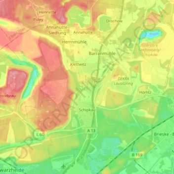
Name: Schipkau topographic map, elevation, terrain.
Average elevation: 123 m
Minimum elevation: 79 m
Maximum elevation: 171 m
Make a donation
Gear up for your next adventure:
As an Amazon Associate, this site earns from qualifying purchases at no extra cost to you.
Other topographic maps
Click on a map to view its topography, its elevation and its terrain.