Geolocate

Lieserwasen topographic map

Click on the map to display elevation.

About this map
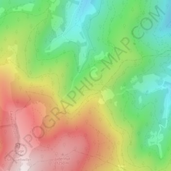
Name: Lieserwasen topographic map, elevation, terrain.

Location: Lieserwasen, Lautenbachzell, Thann-Guebwiller, Haut-Rhin, Grand Est, France métropolitaine, 68610, France (47.91113 7.11007 47.93113 7.13007)

Average elevation: 895 m

Minimum elevation: 550 m

Maximum elevation: 1,324 m

Other topographic maps

Click on a map to view its topography, its elevation and its terrain.
Felsenbach

France > Grand Est > Haut-Rhin > Lautenbachzell > Sengern

Average elevation: 712 m

Gear up for your next adventure:

🥫Freeze-Dried Meals - Lightweight, high-calorie nutrition for multi-day treks
🧥Ultralight Puffy Jacket - Maximum warmth that packs down to the size of an orange
🔭Compact Monocular - One-handed bird watching and trail spotting
🦟Insect Repellent - Keep mosquitoes and black flies away in wooded areas
🥾Waterproof Trail Shoes - Shoes designed to handle wet terrain

As an Amazon Associate, this site earns from qualifying purchases at no extra cost to you.