
Hinterschneid topographic map
Click on the map to display elevation.
About this map
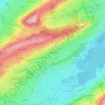
Name: Hinterschneid topographic map, elevation, terrain.
Average elevation: 970 m
Minimum elevation: 870 m
Maximum elevation: 1,139 m
Other topographic maps
Click on a map to view its topography, its elevation and its terrain.
Wertacher Hörnle
Deutschland > Bayern > Landkreis Oberallgäu > Wertach
Der Aufstieg kann von verschiedenen Seiten aus erfolgen. Vom Ortsteil Obergschwend zwischen Ober- und Unterjoch über die Buchel-Alpe ist er in ungefähr eineinhalb Stunden zu schaffen. Von Oberjoch aus kann man über die Hirsch-Alpe und einem Abstecher zum Spieser auf das Wertacher Hörnle gelangen. Aus…
Average elevation: 1,373 m