
Make a donation
Gear up for your next adventure:
As an Amazon Associate, this site earns from qualifying purchases at no extra cost to you.
El Encinar topographic map
Click on the map to display elevation.
Make a donation
Gear up for your next adventure:
As an Amazon Associate, this site earns from qualifying purchases at no extra cost to you.
About this map
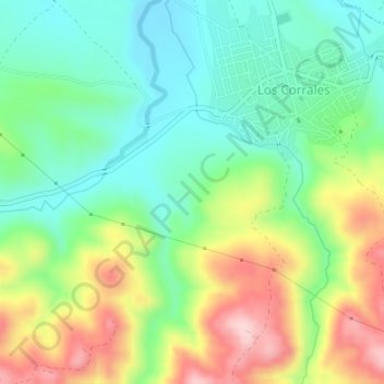
Name: El Encinar topographic map, elevation, terrain.
Location: El Encinar, Los Corrales, Sevilla, Andalucía, 41657, España (37.08199 -5.00204 37.10199 -4.98204)
Average elevation: 422 m
Minimum elevation: 336 m
Maximum elevation: 567 m
Make a donation
Gear up for your next adventure:
As an Amazon Associate, this site earns from qualifying purchases at no extra cost to you.
Other topographic maps
Click on a map to view its topography, its elevation and its terrain.
Los Corrales
España > Andalucía > Los Corrales
Se encuentra situada a una altitud de 385 metros y a 107 kilómetros de la capital de provincia, Sevilla. La ciudad de Málaga se sitúa a unos 105 km.. También están muy cerca las provincias de Cádiz y Córdoba.
Average elevation: 461 m