
Make a donation
Gear up for your next adventure:
As an Amazon Associate, this site earns from qualifying purchases at no extra cost to you.
Provincia de Maipo topographic map
Click on the map to display elevation.
Make a donation
Gear up for your next adventure:
As an Amazon Associate, this site earns from qualifying purchases at no extra cost to you.
About this map
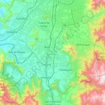
Name: Provincia de Maipo topographic map, elevation, terrain.
Location: Provincia de Maipo, Santiago Metropolitan Region, Chile (-33.98839 -70.98889 -33.52398 -70.47520)
Average elevation: 829 m
Minimum elevation: 244 m
Maximum elevation: 3,070 m
Make a donation
Gear up for your next adventure:
As an Amazon Associate, this site earns from qualifying purchases at no extra cost to you.
Other topographic maps
Click on a map to view its topography, its elevation and its terrain.
Parque Rio Colina Norte
Chile > Santiago Metropolitan Region > Provincia de Chacabuco > Colina
Average elevation: 672 m
Farellones
Chile > Santiago Metropolitan Region > Provincia de Santiago > Lo Barnechea
Average elevation: 2,243 m
Villa Alegre
Chile > Santiago Metropolitan Region > Provincia de Melipilla > Melipilla
Average elevation: 144 m
Bajos de Matte
Chile > Santiago Metropolitan Region > Provincia de Maipo > Buin
Average elevation: 482 m
Make a donation
Gear up for your next adventure:
As an Amazon Associate, this site earns from qualifying purchases at no extra cost to you.