Geolocate

Keystone Heights topographic map

Click on the map to display elevation.

About this map

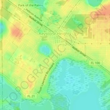
Name: Keystone Heights topographic map, elevation, terrain.

Location: Keystone Heights, Clay County, Florida, United States (29.76894 -82.04661 29.79263 -82.02162)

Average elevation: 41 m

Minimum elevation: 21 m

Maximum elevation: 59 m

Other topographic maps

Click on a map to view its topography, its elevation and its terrain.

Fleming Island

United States > Florida > Clay County

Average elevation: 19 m

Oakleaf

United States > Florida > Clay County > Oakleaf

Average elevation: 18 m

Brewers Landing

United States > Florida > Clay County

Average elevation: 4 m

Middleburg

United States > Florida > Clay County > Middleburg

Average elevation: 10 m

Bellair

United States > Florida > Clay County

Average elevation: 12 m

Gear up for your next adventure:

🥾Mountain Trail Shoes - High-traction shoes for mountain trails
🦯Trekking Poles - Reduced impact on joints for steep topographic climbs
🧤Rechargeable Heated Gloves - Extreme warmth for Canadian winter expeditions
🧢Sun Protection Cap - Breathable cap to protect from sun exposure
💡LED Headlamp - Hands-free illumination for night hiking and camping

As an Amazon Associate, this site earns from qualifying purchases at no extra cost to you.